The city of Harbin in Northeast China’s Heilongjiang Province was hit by extreme strong winds and sandstorm weather at around 5 pm on Sunday, with gusts reaching level 13 and visibility in some areas dropping to less than 100 meters, as fierce winds swept sand and dust through urban areas and briefly turned daytime as dark as night, China Central Television (CCTV) News reported.
During Sunday daytime, affected by strong warm air, temperatures across Heilongjiang rose sharply while winds strengthened. Maximum temperatures in most parts of the province exceeded 30 degrees Celsius, with Harbin reaching 35.3 C, allowing sufficient unstable energy to build up in the atmosphere, said Zhao Ling, chief forecaster at the Heilongjiang provincial meteorological observatory, CCTV reported.
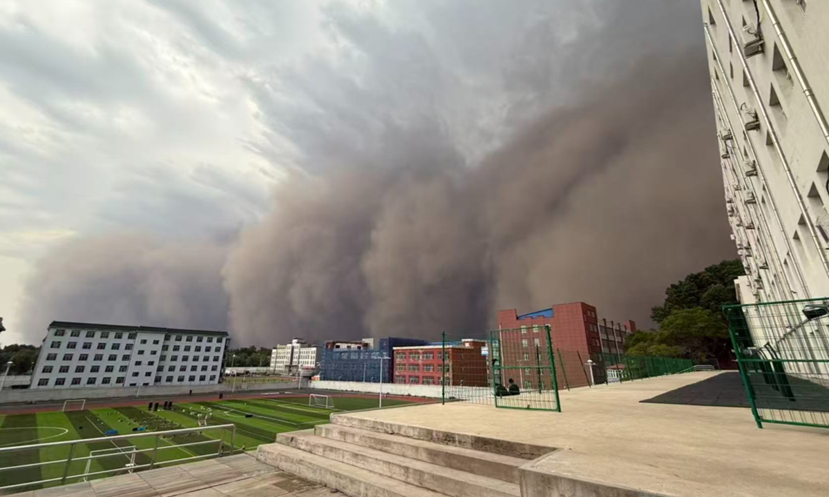
At around 3 pm, strong cold air rapidly moved into Heilongjiang from west to east, triggering the release of unstable energy and forming a band-shaped squall-line, or quasi-linear convective weather system. This has caused cloud cover to surge across central and western parts of the province, including Harbin’s urban areas, darkening the sky while winds continued to intensify. Dry exposed surface soil was lifted locally by the strong winds, resulting in blowing sand weather, according to the report.
According to footage filmed by a netizen and cited by CCTV News in its report, a massive sandstorm cloud was seen slowly moving toward the camera from a rooftop perspective.
Meanwhile, sand and dust weather in Harbin in May is uncommon. Xin Xin, chief weather analyst at China Weather TV Channel, said that an upper trough and a surface cyclone moved eastward on Sunday, affecting eastern Inner Mongolia and Northeast China, and forming a frontal system in the region, according to CCTV.
Xin said the temperature contrast before and after the front was very strong. Many parts of the province first experienced pre-frontal warming on Sunday afternoon, with Harbin seeing rare high-temperature weather. Later, cold air and a near-surface cyclone brought strong winds, and the collision between cold and warm air led to severe convective weather including thunder, lightning and strong winds.
“It was equivalent to cold air at a near-winter level meeting warm air at a summer level, making both the winds and convection very strong,” Xin said.
Ma Jun, director of the Institute of Public and Environmental Affairs, told the Global Times on Monday that the strong southwesterly winds also helped explain the sand and dust. As the winds passed through relatively dry and sandy areas such as western Jilin Province, surface dust was easily lifted and then carried toward Heilongjiang, leading to the fast-moving sand and dust weather.
Affected by the extreme weather, trees in many parts of Harbin’s urban area were toppled, vehicles were damaged, and some power lines were damaged. Local urban management, landscaping and power supply departments are carrying out emergency response work including removing fallen trees, cleaning roads and restoring electricity supply, according to CCTV News report.
On Monday morning, authorities in Heilongjiang issued a weather advisory, forecasting that frequent rainfall, recurring severe convective weather and fluctuating lower temperatures across the province over the coming week. Most areas are expected to experience thundershowers, while some areas may see tornadoes accompanied by strong thunderstorm winds, hail and other severe convective weather, according to Heilongjiang authorities’ official WeChat account.